Showing posts with label railroad. Show all posts

Saturday, March 11, 2023

Railroad Crossing at Tower 26, Houston, Texas (TX 02)

Houston from Tower 26,West Street, 5th ward (250mm ƒ/5.6 Hasselblad Sonnar lens, yellow-green filter)

Three railroad lines cross at a junction in northeast Houston called Tower 26. There is no tower there any more, but the name has lingered. It appears to be a popular spot for railroad photographers because it has public access via West Street. Serious freight trains thunder by on regular intervals. 

I had been looking for an interesting place to photograph railroads and drove to Tower 26 on December 17 of last year (2022). A fellow came up to me rather excited and asked if I was there to see the classic xxx rail cars. I was not quite sure what he was describing, but in a few minutes, the Polar Express trundled by, complete with restored passenger cars containing kids wearing their pajamas and at least one Santa Claus. OK, I had not expected that. What timing. 


Modified Polar Express rail car with picture window (80mm Planar-CB lens, no filter)
Polar Express en route back to Galveston
View east from Tower 26 junction (80mm Planar-CB lens)
Rail line junction, view east to downtown Houston (50mm ƒ/4 Distagon lens)

Tower 26 is northeast of the downtown in the district formerly known as the Fifth Ward. Some of it is pretty rough. I saw some abandoned cottages near the tracks of the type that remind me of west Jackson (Mississippi).

1510 West Street (med. yellow filter)
Facing the tracks, no address
Ready to move in, 2404 Brooks Street


Update March 26, 2023: These little cottages have recently been demolished. The land is bare and freshly scraped. Tractors and trucks were parked near the site. 

Standby for more photographs in the Fifth Ward. 

I took these photographs on Kodak Panatomic-X film with my Hasselblad 501CM medium format camera. Praus Productions in Rochester developed the film. I scanned it on a Minolta Scan Multi film scanner using the Tri-X 400 6×6 profile. The Silverfast software does not have a Panatomic-X profile, but the Tri-X showed the right tonality.


My Hasselblad 501CM with 80mm ƒ/2.8 Planar-CB lens and correct hood

Update April 15, 2023: I returned to Tower 26 on March 26. I met a gent (an MD from MD Anderson Hospital) taking photographs. When I told him I had taken some frames of the Polar Express, he said he was on that ride with his young son. He sent me a clip from the video he took during the ride. It can be a small world among photographers.


Dorky photographer with his Hasselblad at Tower 26


Saturday, December 4, 2021

Levee Street Railroad Yard, Vicksburg, Mississippi


The Kansas City Southern rail yard on Levee Street usually has interesting patterns, shapes, and textures to photograph. Long-term readers know that I have photographed here many times before, but I usually find new material when I explore. Nowadays, it is a rare treat to walk next to or within a rail yard that is not fenced off with security razor wire. The two big rail yards in Jackson are off-limits. 

Fairground Street Bridge, closed since the early 1990s

The rail yard is much quieter than it was before the 2011 Mississippi River flood. I do not know where all the rolling stock went. For older articles on Levee Street:

These photographs are from Kodak Ektar 100 film. I used a venerable Honeywell Pentax Spotmatic camera. Most of the rail yard photos are with my 135mm ƒ/3.5 lens, an inexpensive optic in its day but excellent mechanical and optical quality. Northeast Photographic in Maine developed the film and scanned the negatives with a Noritsu system. I reduced the saturation with Photoshop CS6 software.

Thursday, November 4, 2021

Railroad Town: Skykomish, Washington

Undated photograph, approx. 1920s, from Skykomishwa.gov

Skykomish, a historic railroad town, is on the first flat terrain west of Stevens Pass in the North Cascades in Washington State. The town had a raucous railroad and mining history. From Skykomishwa.gov:

Skykomish, known affectionately by railway employees, rail fans and it's citizens as "Sky" got its start in life from the Great Northern Railway. In 1889, James J. Hill (the Empire Builder) decided to extend his railroad from Montana all the way to the Pacific Ocean. Mr. Hill hired John F. Stevens, famed as the builder of the Panama Canal and his work with the China-Trans Siberian Railroad, to determine the exact route of the railroad.

After discovering Maria’s Pass in Montana Mr. Stevens continued west to Spokane and the Columbia River. Crossing the Cascade Mountain Range they settled on building the railway through the pass that now bears his name.

John Maloney was hired to help survey and design the railroad and was advised to develop a homestead seventeen miles east of Steven’s Pass, in an area called the “flat spot”.

Later, during the construction of the railroad in 1892, the soon to be town, was called “Maloney's Siding”. The depot was a boxcar sidetracked for this purpose. After completion of the railroad in 1893 a post office was established and the town became known as “Skykomish”. The town was platted in 1899 and it was incorporated on June 5, 1909. Mr. Maloney built a store to supply the needs of railroad men.
The town contained a roundhouse, shops, coal yard, and switching equipment. In 1927, the Great Northern started to use electric locomotives to pull the trains through the Stevens Pass tunnel. At first, I was perplexed why the railroad switched to electric. Maintaining electric pylons and overhead lines in the hahsh winter climate must have been a maintenance challenge. Then I read that the issue was ventilation and smoke in the tunnel. Railroad companies had learned that the fumes from coal locomotives could be deadly in tunnels, especially if the train was forced to stop. Eventually, ventilation was installed in the Stevens Pass tunnel and today, diesel locomotives provide the traction for goods trains. There are no electric pylons now.


Skykomish is quiet nowadays. Route 2 bypasses the town to the north across the South Fork of the Skykomish River. Most travelers rush past the turnoff. This the same US 2 that will take you to the Upper Peninsula of Michigan and then, via another segment, to New Hampshire and Maine. I do not remember stopping in Skykomish in the 1970s when I lived in Washington.


 BNSF trains thunder through town, but the shops and depot are gone.


A young couple owns the historic Skykomish Hotel on East Railroad Avenue (click the link to read the long sordid history). The lady runs the Sky River Coffee shop, and the gent is repairing and overhauling the building with intent of opening vacation rentals. The hotel was formerly on the Washington Trust for Historic Preservation "Most Endangered Places" list.  


Many of the historic buildings in town have burned. This is the architectural fate in so many older towns throughout the country.


The 1922-vintage Cascadia Inn Cafe & Lounge is open for business. Railroad view and train noises.

This was our short tour of Skykomish. Stop the next time your drive though the north Cascades on US 2 and grab a coffee at the Sky River.

The photographs are from a Fuji X-E1 digital camera.

Wednesday, June 9, 2021

Pearl Street Houses, Vicksburg, Mississippi (North of Klein Street)


North portion of Pearl Street photographed from the newly-built rail embankment and track relocation. The embankment occupies the site of the former Mississippi Lumber Company (K25 film, Nikon F3, 105mm ƒ/2.8 macro-Nikkor lens) . 
This grade crossing at Klein Street is now permanently blocked.

This is the last article in my survey of Vicksburg's Pearl Street houses, covering the stretch north of Klein Street. The previous articles covered:


Pearl Street east side


501 Klein Street (digital image)
501 Klein Street 
No. 501 Klein Street, at the corner of Pearl, was on the city demolition list, as shown by the spray-pained "DEMO" sign. But as of early 2021, a work crew has been painting and repairing the house.

Around 1989 or 1990, the owner of this house imported some pieces of the Berlin Wall. They were so heavy, they came in by truck. My friend at Annabelle told me that the Berlin Wall guy planned to sell pieces as souvenirs. However, the pieces looked like nasty grey chunks of concrete, and there was nothing to uniquely identify them with the Wall. They languished on the side yard for a decade or more and finally disappeared. I suspect Vicksburg is not quite the right market in which to sell Cold War nostalgia or GDR souvenirs.
2123 Pearl Street in 2003 (Kodachrome slide, 50mm ƒ/2 Summicron-DR lens)
2123 Pearl Street (Panatomic-X film, Pentax Spotmatic, 55mm ƒ/1.8 Super-Takumar lens)
2123 Pearl Street was in good condition in 2003, but then deteriorated to the stage where the city inspector placed it on the demolition list. But as of 2021, it has been painted and repaired.

Pearl Street West Side


Railroad Avenue (below Klein), view west (Panatomic-X film).
The view west down Railroad Avenue is rather bleak, especially on a rainy day. I do not remember when houses lined the street.
2014 Pearl Street (no longer extant; Kodachrome 25 slide)
2004, 2006, and 2008 Pearl Street (Kodak Ektar 25 film, Rolleiflex 3.5F Planar)
2008 Pearl Street
2006 Pearl Street
2004 Pearl Street (no longer extant)
These little cottages had their front porches at street level, while the rest of the structures were perched over the hillside, supported by wood piles. This was a common construction practice early in the 20th century in this hilly city. But today, the buildings cannot be rebuilt on these lots once they have been condemned. These steep hillside lots becomes uninhabitable. 
1804 Pearl Street (no longer extant; Kodak BW400-2 film, 5cm ƒ/3.5 Elmar lens)
The City demolished a large number of these houses in the early 2000s. I do not have more photographs. These were approximately across the street from the warehouses that were part of the Mississippi Lumber Company (1900 Mulberry Street). 

Pearl Street Heading Downtown


Pearl Street view south past Mississippi Lumber Company sheds
Pearl Street view north
Pearl Street view north towards the Harrah's Casino hotel
The hotel in this photograph, originally built by Harrah's Casino, has been closed for at least a decade. As usual around here, there appears to be no status. 
This photograph shows the new section of track built by the Kansas City Southern railroad to reduce the radius of the curve where the rails turn east and pass under Washington Street. The older track, on the right, was such a tight turn, rail cars regularly derailed.

Dear readers, this ends our short series on Pearl Street. I hope these photographs will remind former residents of what the neighborhood looked like decades ago.

Tuesday, April 27, 2021

Tracing Vicksburg's Rail Line South

Introduction


Most Vicksburg residents are familiar with the convoluted route that the Kansas City Southern freight trains take through town. Trains cross the old Mississippi River Bridge, turn north, and either go to the rail yard at Levee Street or ascend parallel to Pearl Street and then turn inland to head towards Jackson. However, there is also a southern extension that now gets little use. At one time, the tracks ran as far south as Eaton Lighting off US 61 south (near the municipal airport), and trains would have served Eaton, the now-defunct Mississippi Chemical Company, and other industries. 

The history of rail in this area is complicated, and I can't begin to understand it. In the late 1800s, several companies extended tracks almost as far south as the Big Black River. In 1883, the Louisville New Orleans & Texas Railroad absorbed existing track and rebuilt it to standard gauge to use for part of their Memphis-Vicksburg-Baton Rouge-New Orleans main line. I do not know when this service ended, but today, no track extends south of approximately Magnolia Road (near Rainbow Farms). No tracks have run to Port Gibson in many decades.

I have shown pictures of the Kansas City Rail yard at Levee Street before. My articles in Trackside Photographer or here at Urban Decay trace the main KCS line through Vicksburg. Here I will trace the lesser-used track that runs to the south starting at the Frontage Road (north of I-20). Access is limited; maybe I should build one of those rail-bicycles that some people use to ride on defunct rail lines. Surprisingly, the Mapquest map still shows the rail line all the way south to Fayette, even though the tracks have been gone for decades. If you look at the map and then switch to the satellite view, you can often see vegetation or property boundary changes that mark the former rail embankment. 

Southern Route


Red circles mark locations of the following photographs proceeding north to south (from ESRI ArcGIS)
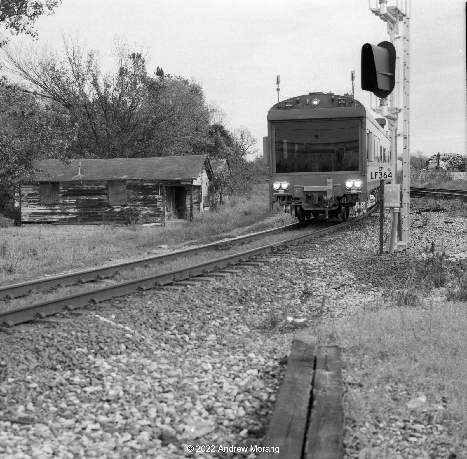
KCS tracks from Frontage Road (Fomapan 100 Classic film, Hasselblad 501CM camera, 80mm ƒ/2.8 Planar-CB lens)
This is where the southern line starts. The track at the lower right is the one we will follow in the following photographs. 
Frontage Road bridge (Tri-X film, Hasselblad 501CM camera, 80mm ƒ/2.8 Planar-CB lens, green filter)
The rail lines run on the opposite (west) side of Stouts Bayou. The bayou is just beyond the brush in the photograph above and the track is visible in the clearing.
Rail line passing under I-20 bridge (GAF Versapan film, Spotmatic II, 135mm ƒ/3.5 SMC Takumar lens, yellow-green filter)
Rail line next to Iowa Blvd. (GAF Versapan filmVoigtländer Vito BL camera)
Iowa Boulevard drops down from the Frontage Road near the Parkside Play House and passes under I-20. Many people take this road as a shortcut to Walmart. The track here also passes under I-20 and runs straight through woods with the next access at Rifle Range Road.
At Rifle Range Road, the track splits. One branch crosses a nasty creek and leads to Halcros Chemicals. The right track above continues south a short distance.
Halcros Chemicals, Rifle Range Road (Tri-X film, Hasselblad 80mm lens)
As this photograph shows, an occasional tank car is brought to Halcros Chemicals. These tracks once continued further south (beyond the sheds) and served the Mississippi Chemical Company. According to Google Maps aerial photographs, those tracks are gone. 

Mississippi Chemical operated from 1953 to 2002, when the parent company declared bankruptcy (according to The Vicksburg Post). Over the years, the company made pesticides, fertilizers, rocket fuel, nerve gas, and other industrial chemicals. Toxins and arsenic seeped into the ground, and part of the area needed to be cleaned as a Superfund site. How many rail cars carried rocket fuel or nerve gas on these tracks over the decades?
Wood bridge with Halcros Chemical beyond (Panatomic-X film, Spotmatic camera, 35mm Super-Takumar lens, fill flash)
Unused (abandoned?) timber rail cars (Panatomic-X film, Spotmatic camera, 55mm ƒ/1.8 Super-Takumar lens, yellow-green filter)
The other track (the one on the right side in the photograph above) only continues a few hundred meters south until you come across abandoned (or permanently parked?) timber railroad cars. They seem to continue indefinitely. What are they here? Are the wheels and steel not worth reusing?

Beyond the timber rail cars, the track continues almost to Warrenton Road, according to Google Maps. At Warrenton, the rails are gone, and the old bed under the bridge has grown in so much, you can't tell that track once ran there.
Former rail embankment at Willow Drive, view south (Tri-X film, Hasselblad camera, 250mm Sonnar lens, yellow-green filter)
Former rail embankment at Mop Lane, view north
Further south, the old embankment is being mowed by someone. Why? Will this right-of-way be used by some entity? 

Just north of the Vicksburg municipal airport, tracks once turned west into the Westinghouse (later Cooper and now Eaton) electrical equipment factory. A friend who started work at Westinghouse in 1976 said rail cars delivered heavy materials, like coils of copper, for about two years (until about 1968). Afterwards, trucks delivered all supplies and eventually Westinghouse removed the rails and changed the loading dock. 
Warrenton Lane (GAF Versapan film, Voigtländer Vito BL camera)
By the time you reach Warrenton Lane, near the Cedars Elementary School, the right-of-way is overgrown. You can see a bit of track disappearing into the brush.

A few miles south, only a short stub of track remains near the former Marathon Letourneau plant at Letourneau road. Further south, the terrain is wooded, and the railroad right-of-way is hidden or lost. But you can trace the former right-of-way on aerial photographs.

Port Gibson


Former rail line under Ingleside Karnac Ferry Road (GAF Versapan Film, Vito BL camera)
As I wrote above, decades ago, the rail line extended south to Port Gibson and then further to Baton Rouge. I was not sure if I could find any remnants of the old line, but while driving on Ingleside Karnac Ferry Road, I was surprised to cross a modern bridge over a distinctive V-shaped valley. A dirt road ran in this valley, but the large amount of gravel gave it away and the former rail line. The photograph above is from the bridge looking north.
Depot, Market Street, Port Gibson (GAF Versapan film, Vito BL camera)
The 1884-vintage Yazoo and Mississippi Valley Railroad depot is in Post Gibson at 1202 Market Street. It was converted into a restaurant in 1977 but is not in use now. Many of these railroad depot restaurants do not last long. Someone ambitiously renovates the buildings, but after a short burst of energy, the restaurant closes. A Mississippi Department of Archives and History Historic Sites Survey describes the depot. 

This has been our short excursion on the southern rail extension. Thank you for riding along.