Tuesday, February 22, 2011

The Betigheimer Store, Edwards, Mississippi

Country stores in Edwards, Mississippi. Map drawn with ESRI ArcMap software.
The Betigheimer country store on Betigheimer Road and MS 27.
The previous two blog entries dealt with Margaret's Grocery. These small rural stores are cultural elements of the southern scene that are rapidly disappearing. They are fascinating photographic subjects and I will show more examples in the future. The subject of this essay is the Betigheimer store, formerly located at the corner of Hwy. 27 and Betigheimer Road, near Utica, Mississippi. The first time I photographed it was in 1986, when it was being used as an antique store.

A coworker who grew up in Utica told me he used to shop there as a child. He remembered buying his first cookies there, two for a penny (I didn't ask what century this might have been). He was intrigued by the fact that Germans ran a country store in a rural African-American community. How did they end up in a place like Utica? At the time, it was a classic country store, selling hardware, seeds, food, tools, nails, and useful supplies. He could not remember when it ceased business as a general merchandise store. The Betigheimers lived in a large wood house just east of the store, but it was struck by lightning and burned down sometime in the 1980s. A modern house is on the lot now.

When I returned in 1997, the antique business had closed, but there was a lot of old-fashioned machinery (junk) strewn about the yard. Nice stuff, but not much was happening.

The store burned sometime around 2000. I rarely drove on Hwy. 27, and one day in the early 2000s, it struck me that the store was gone. Sad, another piece of our heritage gone.
1986 Tri-X photograph of the Betigheimer store taken with a 4×5" Tachihara camera and 180mm ƒ/5.6 Caltar IIN lens.
The first color photograph above is a Kodachrome 25 transparency taken with a Rollei 35S camera with f/2.8 Zeiss Sonnar lens. The next three are Kodachrome 25s taken with a Leica M3 rangefinder and 35 mm f/2.0 Summicron-RF lens (the famous 8-element version with the finder goggles). I scanned the transparencies as TIFF files with a Nikon Coolscan 4000 film scanner.

Update June 2020: the last photograph is a black and white Tri-X frame from a 4×5" camera.

Friday, February 11, 2011

More Views of Margaret's Grocery, N. Washington Street, Vicksburg


I found some more old photographs of Margaret's Grocery at 4535 North Washington Street that I wanted to share with you readers. The first is another April 1996 view of the north end of the complex. Notice the bus is already in place. I had not noticed it before and am not sure when this acquisition was added to the collection.

Here is the bus in March 2002, with its checkerboard paint motif. I took this late in the day, when the light was fading. This is a Kodachrome slide taken with a Leica rangefinder camera and a 20 mm Russar lens.

Finally, here is the unique doorway with newspaper clippings from around the country describing the Gro. It was an amazing place and I wish I had taken more photographs back in its prime.

Tuesday, February 8, 2011

Margaret's Grocery, Vicksburg, Mississippi: the Early Days


Margaret's Grocery at 4535 North Washington Street is an amazing piece of folk art crafted by the Reverend H.D."Preacher" Dennis. Many people have photographed the site, including the talented local photographer Marty Kittrell (see his blog), but I would like to add some photographs from my 1980s and 1990s archives. This first photograph is from December 1985, soon after H.D. married Margaret Rogers. At that time, it really was a local grocery store catering to nearby residents from the Kings neighborhood. There were just a few of the hand-crafted decorations that later transformed the humble shop.
By 1988, look at the brickwork! Reverend Dennis is the tall gent framed by the brick arch. He was proud of his work, and as many locals know, once he started talking about his love for the Lord and his temple, he went on, and on, and on... He told me that at the end of World War II, he worked as a prison guard for German prisoners and learned his brick skills from them. He said they were the best craftsmen anywhere. Germans had an affinity for Rev. Dennis because many German tourists visited, as proven by testimonials in German in the guest book. The photograph above is a scan of a 4×5-inch Fujichrome transparency.

You can see how brilliant the colors were when fresh. It was a difficult site to photograph because you needed to be there in the morning when the sun shone on the front. (The two frames above are from Fuji Reala film exposed with a Rolleiflex camera.)

Here is a 1990 detail of one of the towers.

Here is an April 1996 photograph, with a yellow motif along the roof line. The Coca Cola signs along the awning have been painted over.

Along with the exterior, Rev. Dennis was working on the inside. He eventually covered almost the entire ceiling and most of the walls with flowers, clocks, paintings, crosses, and things I can't name. This was a badly underexposed Kodachrome slide from 2002 that took some effort to scan and bring out details from the darkest areas.

I am not sure when the famous bus appeared on the property, but it was there in 2002, already decorated. This was another difficult Kodachrome to scan because the windows were overexposed while the ceiling was dark. Nowadays, digital imaging handles the exposure range much more gracefully.

Margaret passed away in 2010 and the Rev. Dennis had to move to a nursing home. Since then, vandals have stolen art and architectural features, and rain and weathering are taking their toll. In a later blog I will show readers what the Gro looks like today. The Vicksburg Post has featured Margaret's Grocery several times over the years, with the most recent article on 15 August, 2010.

Back in the 1980s, North Washington Street had a number of odd places to see. Here is a former Corvair junk yard. I wonder where they all went? People restore Corvairs now.

Sunday, January 30, 2011

The Packard Showroom: 913 Washington Street, Vicksburg, MS


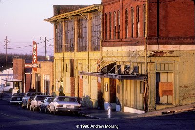
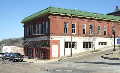
North Washington Street was once a busy commercial thoroughfare, but over the years, many of the warehouses and shops have been torn down. One of the few survivors is this 1911-vintage automobile showroom at 913 Washington Street. A Vicksburg Post article (27 December 2010) states the building was originally used for wagon and carriage manufacture but was later a Packard showroom. I found a June, 1990, Kodachrome slide in my archives which still shows a Packard sign.

The Packard web site does not list McKay Motors but does list a dealer called Christian & Brough Company at 919 Washington Street.
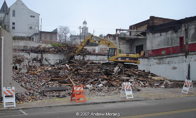
Today, only the southern section of the building stands. The center unit was dismantled by the City of Vicksburg on February 1, 2007. The roof had deteriorated but several people have told me that the building was not in such dangerous condition that it could not have been saved. This section may have once housed a 7-Up bottling plant, which was in operation in the 1950s.

During the 1970s through the early-1980s, the building housed the Monte Carlo club, which booked nationally-known rhythm and blues bands. In the early 2000s, a club named Faces operated here for a short while. The owner put a lot of effort into fixing and decorating, but I am not sure why it closed. The good news is a local businessman, Mr. Malcolm Carson, has bought the building and is in the process of cleaning and renovating it.

The interior still has some of its original architectural decorative elements, like this beautiful support.


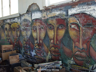
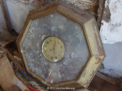
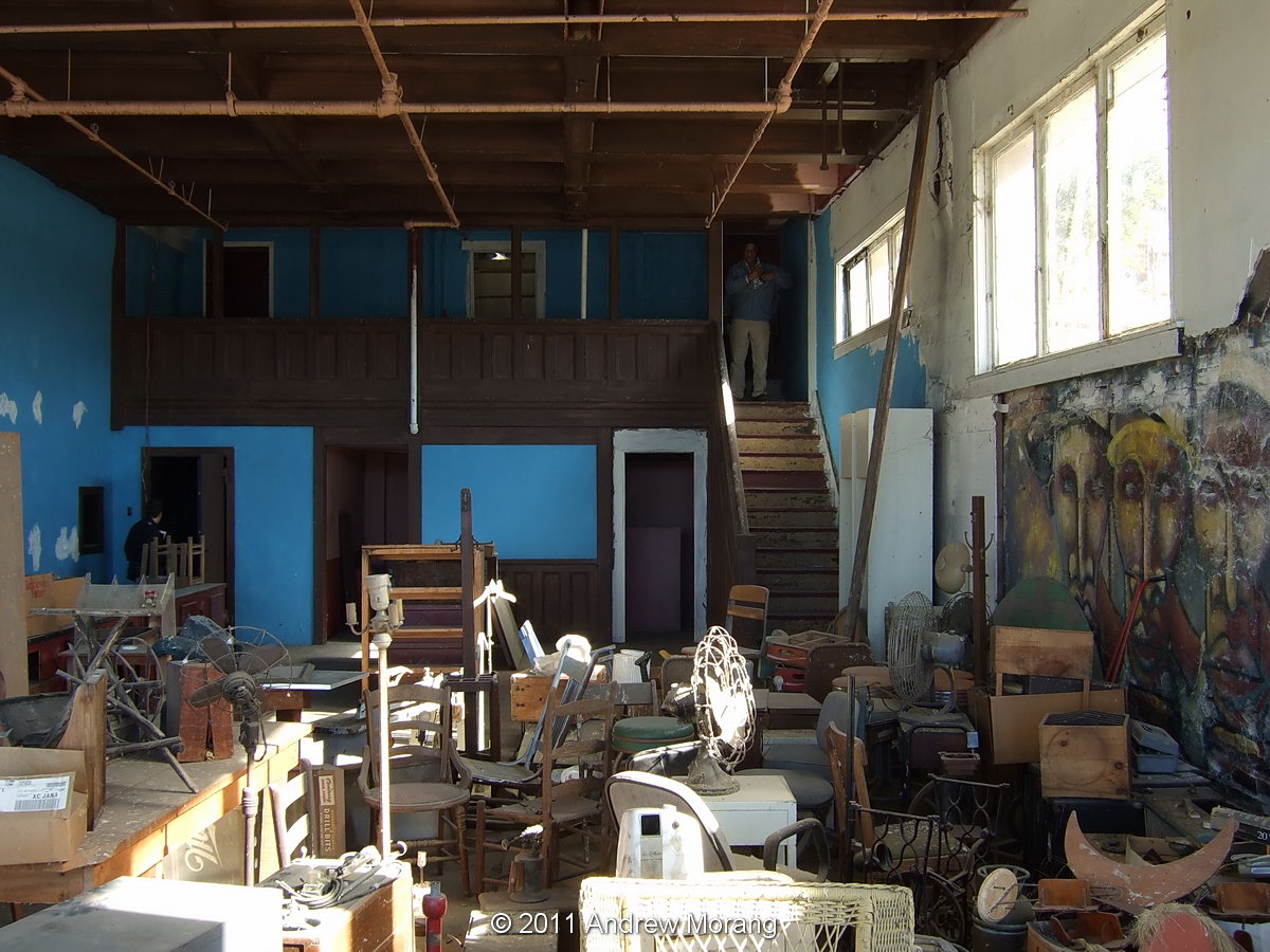
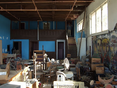
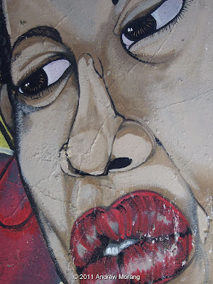
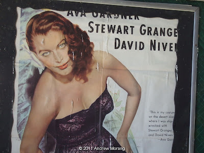
Among the remnants of the "Faces" era are piles of furniture and props and some spectacular murals painted on the walls. The one above is on the ground floor on the south side. The props (debris) include chairs, Victrolas, tables, and clocks.


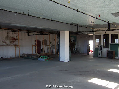
Walk up the stairs to the second floor and you see another wide open space that could have numerous future uses. I was told that this may have once been the automobile repair shop, but I did not see evidence of lifts or hydraulic equipment, and possibly people are thinking of the building next door (the one that was dismantled).


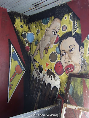
More of these funky murals are on the second floor, the example above at the top of the stairs.


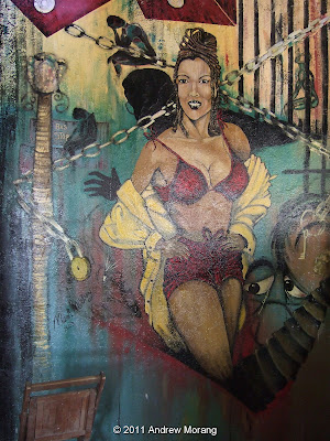
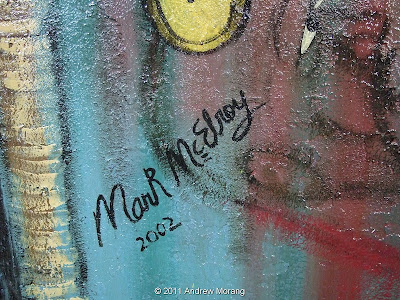
They were painted in 2002 by an artist named Mark McElroy, whose signature appears on the lower right of the mural of the robust lady.


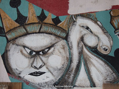
I love the silhouette of the dancing couple, and the scowling lady glares down at the audience from near the ceiling.

There are even movie seats and a signboard amongst the debris.

What can be done with this building? A group of artists and historians may form a non-profit organization to preserve what remains of Margret's Grocery, which is deteriorating rapidly from the weather and vandals. Possibly 913 Washington Street could become a museum of Afro-American heritage. The location is perfect because Vicksburg already attracts tourists, and the Corps of Engineers' Lower Mississippi River Museum and Interpretive Site is right across the street. Maybe we finally have enough momentum to revive downtown.

(All interior images are from a FujiFilm F31fd compact digital camera. Photographs 1 and 2 are scans of Kodachrome 25 transparencies, taken with a Pentax Spotmatic camera and the 150 mm f/4 Super-Takumar lens.)

Saturday, January 22, 2011

Jo-Anna Motel, North Washington Street, Vicksburg, Mississippi

North Washington Street runs from downtown Vicksburg to the junction with 61 bypass. On the east side of Washington Street, near the turnoff at Haining Road, which leads to the Port of Vicksburg, sat the Jo-Anna Motel (address 1750 Washington St.). The brick rooms were arranged in an en echelon pattern with a two-floor unit at the north end. A friend told me she remembered when it was built in the late 1940s or early 1950s. According to the Preservation in Mississippi blog, the architect was N.D. Galo, presumably of Vicksburg.

The Jo-Anna was typical of the American trailer court, catering to a post-war generation on the move. With flowers in the planters out front, it was probably a cheerful place in its prime. But since the 1980s, it was nasty-looking, and I recall seeing equally rough cars parked there. However, some renovations had been made, and the asbestos tile roof was replaced with a new metal roof in the 1990s.

The Jo-Anna once had an attached restaurant. My friend said she remembered going there with her parents for Sunday dinner. But as you can see, the restaurant had converted into a beer joint of seedy disposition.

At least they asked patrons to not bring their weapons. Maybe the establishment provided them. All the buildings were purchased by the Park Service and demolished around 2005 or 2006. The land is now part of the Vicksburg Military Park but is not being used.

This scan of a post card is courtesy of a friend who writes the Preservation in Mississippi blog. Notice this shows the units to have flat roofs. Also, the artist took some geological liberty when drafting the post card: the hill behind does not exist. Maybe tectonics since the 1950s resulted in some orogeny (mountain-building).....
Update August 20, 2014. I found the origin of the postcard. It is from the Tichnor Collection at the Boston Public Library. Some 25,000 post cards from the BPL are posted on flickr.

Friday, January 14, 2011

Collapse! 515 Clay Street, Vicksburg, Mississippi

515 Clay Street, January 25, 2006
One cold day in January of 2006, Vicksburgers were astonished to hear that the building at 515 Clay Street had collapsed. The parking garage across the street provided a great view of the site, and as you can see from the first photograph, part of the building crumbled out into the street, squashing a car in the process.
515 Clay Street, January 25, 2006
In the mid-1980s, I remember visiting the Thomas furniture store on the lower floor. It occupied an old-fashioned store lined with elegant tall wood shelves. A set of ladders on rails paralleled the shelves, allowing a clerk to climb high to retrieve merchandise. Some libraries had the same type of rolling ladders. I am sorry I never photographed in there; it looked like a time warp from the 1920s.
In the following days, we learned from the Vicksburg Post that the building was being renovated by a couple who moved here from New Orleans. Some workers had cut some joists in the morning of the 25th, and in early afternoon, heard ominous creaks and groans. They rushed out just in time to avoid being squashed.
So what happened? Look at the way the building was built, which was typical of late 1900s commercial buildings in the United States. The vertical bearing walls are three bricks thick. To support a joist, it is inset into the wall by only the width of one brick. The reason why the joist did not penetrate completely through the wall was that, theoretically, if it broke or failed, it would pop out of its support ledge rather than cantilever out and pull the wall down as it rotated downward. As long as the walls continued to stand, new joists could be installed and the building rebuilt. By the way, this kind of construction is deadly in an earthquake.
In the enlargement above, look at how the horizontal beam on the left only penetrated one brick into the wall. The top was tapered away from the wall to ensure that it would tip down without catching the wall. The beam on the right failed exactly as designed. But obviously, something went wrong and the front part of this building collapsed along with the floors.
The sordid saga continued for four years. The city and the building owners argued over who was responsible for cleaning up the street. Half of Clay Street was blocked for over a year. Then the owners wanted to raze the whole structure; the city wanted part of it saved. Years went by with almost nothing happening. We're not known for high speed action here in Vicksburg. As you can see in the last photograph, now all that remains is a piece of the cast iron framework and a window. Sad, another piece of our architectural heritage lost.
Clay Street, date not recorded. Postcard from Mississippi Department of Archives and History
This is what the block looked like sometime in the early 1900s. Vicksburg was a prosperous and real city then, with electric trolleys and commerce and industry. The postcard is from the Cooper collection at the Mississippi Department of Archives and History.

Photographs of the collapse taken with a Sony DSC-W7 compact digital camera.

Saturday, December 25, 2010

Update: Mississippi Basin Model - Further Decline

Dear Readers, bad news: what is left of the famous Mississippi Basin hydraulic model in Jackson (in Butts Park off McRaven Street) has deteriorated noticeably in the last year.

This was the largest hydraulic model in the world, meaning it covered the largest continental land area ever to be assembled into one comprehensive tool to test water flows. It was last used during the 1973 Mississippi River flood when the Old River Control Structure was almost undermined. The structure's failure would have led to a large proportion of the river's flow going down the Atchafalaya River waterway rather then along the present path past Baton Rouge and New Orleans and on to the Balize Delta. The model was maintained through the 1970s but finally discontinued because of the expensive manpower requirements. The land was deeded to the Department of the Interior and subsequently to the City of Jackson in the early 1990s. Since then, trees and brush have covered much of the site, buildings have fallen down, and vandals have damaged equipment and stolen property.
You can get an idea of the vast size of this operation from the photograph above. This is part of the lower Mississippi below Vicksburg. The accordion-folded mesh serves as friction to simulate trees (hardwood bottom land) in the delta plain. This area is not as overgrown as other areas because of the broad expanse of concrete.
One of the compressor houses still has its roof, and the equipment inside is still present. Another one-story building on the site has completely collapsed. Another one suffered a fire so intense that the steel roof joists warped.
In the lower-river control house, a number of the Stevens chart recorders have been stolen since last January. These machines provided a permanent record of a flood in the form of stage hydrographs. They recorded on chart paper with pens, similar to tide recorders and just about every other type of technical data recorder in the mid-20th century.
The punched paper you see above was for the flow controller system. This controlled a variety of orifices in the flow controller tank, which in turn released precisely measured amounts of water to the model. The charts could be played back many times to rerun particular flow events or storms. A coworker told me that at one time, many bookcases were filled with these paper rolls. Fascinating technology, but I can imagine the manpower required.

You can see more photographs of the site in this January 2010 blog entry: Basin Model. If you want to see what is left, visit soon. The deterioration appears to be accelerating. It's really sad to let this historic civil engineering wonder go.

UPDATE JULY 2017:  A volunteer organization has been formed to clean and clear the site and develop it as an education/interpretive center. They have already done amazing work at clearing trees and cleaning off some of the concrete walkways. Readers interested in participating in the cleanup work, please contact: 

Sarah McEwen
President, Friends of the Mississippi River Basin Model
601-376-9131
Twitter: @MSRiverBasinMod
Facebook: @FriendsofMississippiRiverBasin Model