Sunday, December 6, 2015

Last train to Arusha

Dear Readers, sorry, the title is a bit deceptive. There are no trains to Arusha, and I think the last one left the station at least a decade ago. Arusha is a bustling commercial city in north central Tanzania. Most western visitors know it as a gateway to safaris in the Tanzanian game parks or as a gathering point before a climb of Kilimanjaro. Arusha itself does not offer much for the tourist, but it is busy, noisy, grubby, and colorful.

The railroad was built in the early 20th century, during the great era of railroad-building around the world. The official Tanzanian railroad web page states, 

"Construction of the 86.08 km Moshi-Arusha railway extension of the Tanga Line starting at Moshi in 1911 and reaching Arusha in 1929. The railway distance from Arusha to Tanga and Dar es Salaam is 437km and 644km respectively." 

My guide, Morris, said the railroad was built by the Germans. He was partly correct because while the Germans were forced out of their African colonies in World War I, they certainly began the construction project when Tanzania was part of German East Africa. According to Wikipedia, Germany controlled this part of east Africa from the 1880s to 1919, when, under the League of Nations, it became a British mandate.

On my first day in Arusha, I asked Morris to take me to the train depot. He was surprised, and said he had never had a tourist ask him to go there. We took rides with rent-a-motorbike transport guys. Mine had a spare helmet and was very careful, avoiding the rain gutters that line most of the roads. Some of these are serious troughs, about a meter deep and lined with organic debris of unknown aromatic origin. The depot buildings are in a warehouse part of town. Lorries were parked in the dust.
The buildings were intact and secure, so someone still takes responsibility.
The tracks were meter gauge, another remnant of the German origins for this project.
The electric supply from the mains is a bit erratic in Arusha, meaning often there is no electricity.
Were there once 1st and 2nd class outhouse stalls? Odd.
Some gents were sitting at once of the platforms. Morris asked them if I could take their portrait. They said they did not see many white people (Westerners?) around there.
It was pretty sleepy on the track side of the depot. The bugs were buzzing, the sun blazing - time for a nap.
There was not much happening inside, either. The buildings are locked, so someone has possession. I hope they can one day restore train service.
I took these photographs with a Panasonic G3 digital camera with the Panasonic Lumix 12-32mm lens, and added a polarizing filter for scenes with sky. To convert to black and white, I opened the RAW files in Adobe Photoshop Elements (using ACR 7.3), then opened DxO FilmPack 5 to use one of the black and white emulations. Most of the time, the Kodak Tri-X was best, but on some very contrasty scenes, Kodak BW400CN retained detail in the shadows. I usually added the yellow filter to darken the sky a bit.

Tuesday, December 1, 2015

The Trees of Kilimanjaro

Mount Kilimanjaro is a huge dormant stratovolcano in northern Tanzania, near the border with Kenya. The mountain last erupted about 150,000 years ago, but there is still a smoking ash pit in the summit caldera. The mountain is the highest in Africa and may be the highest mountain on earth that can be accessed by hikers without technical climbing equipment or mountaineering skills. It rises about 4,800 metres (16,000 ft) from its base to Uhuru Peak at 5,895 metres (19,341 ft) above sea level. These elevations have been re-surveyed recently and differ by minor amounts from survey to survey. I summited in September, 2015, with three friends and will post some photographs in the coming months.
The map shows our route based on waypoints measured by my friend's Garmin GPS unit. On the way down via the southern route, you descend on the Mweka Trail to the Mweka Gate. Because the elevation changes so greatly, a trekker passes through distinct botanical/biological zones, ranging from alpine desert to jungle. This article is about the Trees of Kilimanjaro*.

* Sorry, I could not resist paraphrasing the title of Ernest Hemingway's 1936 short story, "The Snows of Kilimanjaro". It is about a hunter who is dying of gangrene. The 1952 film stars Gregory Peck, Ava Gardner, and Susan Hayward, with music by Bernard Herrmann. Quite a star-filled production.
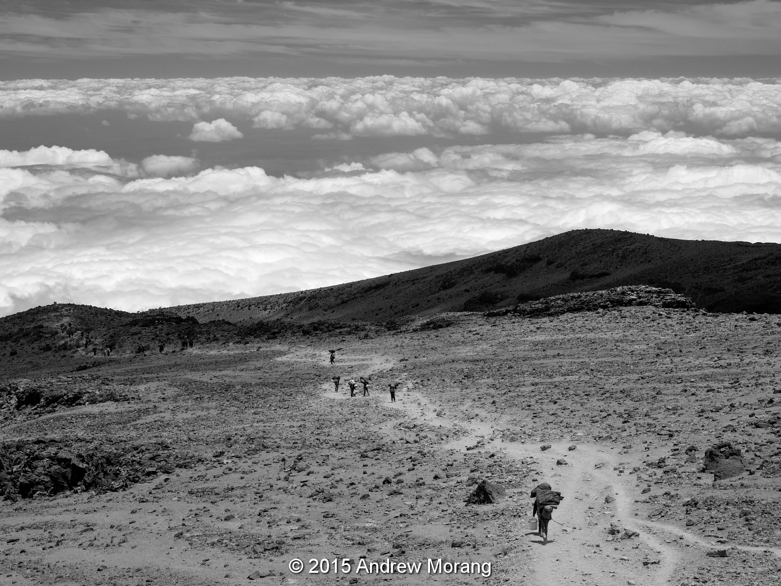
Above Millenium camp, the terrain is a bare, dusty, terrain of rock and ground-up rock powder (see photograph no. 1). But at Millenium, you begin to see stunted trees and brush. And at 12,000 ft altitude, the air feels so thick after sleeping above 15,000 ft for three nights. I guess everything is relative.
Below the Millennium Camp, the trail passes into a spectacular forest of monstrous trees and ferns. It is so Jurassic Park, you wonder when a dinosaur will pop up from a valley. According to Wikipedia, the montane forests on the southern slopes contain Ocotea usambarensis as well as ferns and epipythes, while farther up in cloud forests, Podocarpus latifolius, Hagenia abyssinica and Erica excelsa thrive as well as fog-dependent mosses.
The trail is nicely-graded here and takes you relentlessly down. One thing we noticed is that the trail within the forest was no longer dusty but was hard-packed dirt. The trail crews had dug gutters and water troughs to control runoff in the wet season.
The tree ferns are gorgeous with backlighting.
And then there are the trees. Nothing subtle about this timber.
Occasionally, the view opens to a fern-covered field and vistas of forest.
The trail reaches a jeep track with a resting tree for the porters. These guys are amazing considering the heavy packs, tents, and supplies they carry at over 15,000 ft to support trekking groups.
You continue to pass through a spectacular forest as long as you are in the Kilimanjaro National Park. In the lower areas, local villagers are allowed to harvest something (not sure what) from the forest floor. But they cannot cut timber.
Finally you reach the Mweka Gate at 1640 m elevation. You receive your official certificate (if you summited), as well as lunch and a beer. And if you are really lucky, an air-conditioned van is waiting to take you back to your hotel and a shower. We had a fabulous trip, and I thank Ed, Fred, and Zak for being such cheerful and great companions.

If you want to take your own trip to Kilimanjaro, I strongly recommend Embark Adventures of Portland, Oregon.

Photographs taken with a Panasonic G3 camera with Lumix 12-32mm lens. RAW files opened with Photoshop Elements and processed with DxO Filmpack 5, mostly with the Tri-X film emulation and yellow filter.

Wednesday, November 25, 2015

Mississippi River Basin Model - continuing decay, November 2015

The former U.S. Army Corps of Engineers' Mississippi Basin Model in Buddy Butts Park in Jackson, Mississippi, remains abandoned and neglected by the City of Jackson. As you might expect, the site is more and more overgrown and vandalized than ever. On this visit, my friends and I explored some of the buildings, which are gradually collapsing.
The first building, next to the water tower, was a pump house partly built over a sump. The catwalk is still intact despite the roof collapsing.
 A steel shed once contained air compressors and other machinery of unknown purpose.
This building once contained the Stevens chart recorders and may have been an executive control center for the model. I showed photographs of the old Stevens recorders in my 2010 article, but all have disappeared now.
These shelves once contained rolls of paper with holes representing some sort of coding (octal?). The flow of water via electrical or pneumatically-actuated valves was controlled by these paper strip charts.
This is one of the inflow controllers. I wish it was intact and wish I knew how it worked.
My friends and I came across another building that we had not explored before.
This building contained the remains of two huge air compressors. I am still not sure exactly how the compressed air was used, but it had something to do with the pneumatic controllers and the chart strip recorders.
This viewing platform was once used by tourists who visited the site. In the 1960s, the Basin Model was a popular tourist attraction (as was the Waterways Experiment Station before 9/11). I have read that many of the former German prisoners of war who worked on the site in World War II came to see the functioning model.
The model is a peaceful place on a quiet Autumn afternoon. Visit it soon before the buildings and concrete terrain elements are completely overgrown.

For some earlier articles, please click the links:

Photographs taken with a Fujifilm X-E1 digital camera with a Fujinon 27mm f/2.8 lens. Raw files processed in PhotoNinja software.

UPDATE JULY 2017:  A volunteer organization has been formed to clean and clear the site and develop it as an education/interpretive center. Readers interested in participating in the cleanup work, please contact: 

Sarah McEwen
President, Friends of the Mississippi River Basin Model
601-376-9131
Twitter: @MSRiverBasinMod
Facebook: @FriendsofMississippiRiverBasin Model

Wednesday, November 18, 2015

Old Hattiesburg High School - neglect and decay

Thomas Rosell wrote an article for Preservation Mississippi on November 18, 2015, titled Not Good News from Hattiesburg. He documented the continuing collapse of the historic Easton High School. Thomas's article jogged my memory, and I found some photographs that I took in 2011 during a quick drive through town of the Old Hattiesburg High School at 846 North Main Street. 
This must have once been a handsome and proud building. I had never seen it before and was struck that such an edifice could be abandoned so carelessly. I read in the Hattiesburg American that Hurricane Katrina caused severe damage in 2005, followed by arson in 2007.
I was alone and did not want to venture inside, but I took some photographs of the doorways. Notice the steel bracing behind the handsome limestone entry porch. Hmmm, do our contemporary mega-schools have limestone entry halls?
Like many schools in the early 20th century, there were separate Boys and Girls entrances. But there may be good news: a November 16 article in the Hattiesburg American describes a proposal to develop the building into "age-restricted" housing. 
On a more optimistic note, the Italian Renaissance Revival-style Union Station and New Orleans & Northeastern Passenger Depot, at 308 Newman Street, has been restored and serves as an intermodal transportation center. The city acquired the building and land in 2000 and completed a 5-year, $10 million renovation in 2007. The Grand Hall is now used for art exhibits and social events. It's nice to see gorgeous old buildings like this still in use and respected for their architectural uniqueness.

Photographs taken with a compact FujiFilm F31fd digital camera.