Wednesday, February 10, 2016

To the Top of Africa: Kilimanjaro

Dear Readers, this post will not cover urban or rural decay. Instead, it is about a trek over a fantastic geological terrain, a volcano that has been weathered and eroded for millennia. Mount Kilimanjaro is one of the great topographic wonders of the African continent. The highest part of the summit cone rises to 19,341 ft above sea level, or about 16,000 ft above the surrounding plains.
It must be profoundly rewarding to stand on the highest point on each continent. I will never achieve this in North America, South America, Asia, or Antarctica. But Africa - that is possible for a normal mortal, even one with creaky knees. Mount Kilimanjaro is the highest mountain on earth that can be summited without needing technical equipment or special mountaineering skills. It is a hard trek, but achievable for anyone with altitude acclimation and stamina. I had thought about it for many years and decided I better go before I became too decrepit to make the journey. (The photograph above is from the National Archives, UK).
Climbing Kilimanjaro is different than hiking in many other countries. Unlike USA or Europe, you can't just strap on your backpack and start walking. In Kilimanjaro National Park, you must be accompanied by at least one authorized mountain guide. Most foreign visitors hire a trekking company to make arrangements for a team of guides, porters, and cooks. The porters carry the tents, food, and other equipment, including the foreigners' duffel bags. The visitor walks with just a day pack, and, when he reaches the evening camp site, he is met with a dining tent, food, and hot water. Water is sometimes a long distance from the camp sites, and the porters work hard to carry bottles up and down the trails. The water issue may be one major reason to not try Kilimanjaro on your own without a professional crew. The ratio of Tanzanian workers to foreigners is about 5:1, so our team of four Americans had 26 support staff.
Another interesting note: most trails are one way to reduce congestion. So you ascend on an uphill trail and descend on a downhill trail. Porters can go against the traffic direction as needed, but the main groups all walk in tandem. My three friends and I took the Lemoscho Route, which starts on the western edge of Kilimanjaro National Park. This is one of the longer routes, meaning the foreigners have more days to get acclimated to altitude. Our trip was eight days on the trail, 6½ up and 1½ down. The longer the group spends ascending, the higher success rate. The outfitters who promise to get you up and down in 4 or 5 days have a high failure rate because most tourists suffer altitude sickness. Our bodies simply can't be rushed when adjusting to altitude.
On Day 1, we drove in a minibus from Arusha to the western border of the National Park. The trail starts at the Lemoscho gate, where you check in and the park authorities inspect your permits. These gents were our guides. The fellow on the left was Godlisten Moshi, the chief guide who has summited Kilimanjaro over 100  times. In the center was Dennis, and on the right, Morris. They were unfailingly helpful, polite, and cheerful. Morris was my guide in Arusha for a couple of days prior to the climb.
Then we ascended gently through dense, lush forest to Mti Mkubwa (big tree) camp at 9,000 ft elevation. The porters also check in with the rangers at each camp and have their packs weighed to ensure that they are not being forced to carry dangerous loads. The camp was crowded and noisy, and some obnoxious guys from New Hampshire stayed up much of the night laughing at their own jokes. I yelled at them, and then Godlisten yelled at them. Poor night's sleep.
Day 2, we gained the Shira Ridge and entered the great Shira Plateau, an ancient eroded volcanic lava flow and caldera complex. The vegetation was moorland, with shrubs and cacti. Now the trail was dry and powdery, and every footstep kicked up clouds of ground-up volcanic rock powder. Before long, the dust was everywhere - in your eyes, nose, socks, clothing. You blow your nose and volcanic snot comes out.
Shira 1 camp is at about 11,500 ft elevation. This was a long day and the camp was welcome. The big peak loomed above us, still a long way off. We were tired but glad to be able to see our destination. There is a road on the Shira Plateau but is only for emergency use by rangers or ambulances. The porters must carry all supplies up here. The tall tent in the photograph is the toilet tent, containing a chemical toilet. Some of the camps have latrines, but they are pretty grim.
Day 3 was a nice trek across the plateau to Shira 2 camp, at about 12,300 ft altitude. This was a good day for acclimatization. The camp itself is spread among almost-barren rocks, a bit bleak. None of our team had any altitude issues. But we were advised to drink 4 liters of water a day to help speed altitude adjustment. Four liters means getting up often at night to pee.The Diamox tablets just make it worse.
Day 4 took us up to Lava Tower Camp at 15,200 ft altitude. We still all felt well and walked strong. Consider, this is higher then Mount Rainer in Washington (14,400 ft) or Mt. Whitney in the California Sierras (14,500 ft). The tower is an eroded volcanic plug that looms above the camp. The camp was crowded with, I guess, at least 200 people total. Night was below freeing, and my thick down sleeping bag and thick socks were welcome.
On 
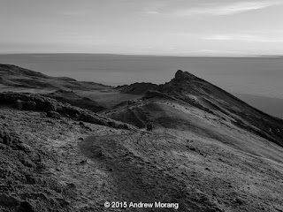
Day 5, we walked up to Arrow Glacier Camp at 16,100 ft. The plan was to stay at Arrow for a couple of hours and then descend to Lava Tower for another night, letting our bodies adapt to the altitude. The terrain at Arrow is bleak. Arrow is the last camp before the Western Breach trail, which ascends to the Reutsch Crater at 19,000 ft. The Western Breach is the most technically challenging ascent to the summit area because it is a steep and rocky scramble. This route is usually attempted by experienced hikers/climbers. In 2006, three climbers were killed by a rockfall, and the route was closed for several years.
For Day 6, the plan was to re-ascend to Arrow Glacier Camp, sleep a short night, then start up the Western Breach at 0100 on day 7. But something went very wrong. A young American couple we had met the day before had started up the Breach, and the man was killed by a rockfall (Mr. Scott Dinsmore, a Californian). The guides had already mounted a rescue, and we saw porters carrying out the body. His young wife survived and we saw a porter carrying her out on his back. Two of our porters were loaned out to that group to help with the transport. Needless to say, Western Breach was closed.
Godlisten developed an alternate plan. We did a forced march around the summit along the Southern Circuit, past the Barranco Hut (12,900 ft) and a scramble up over the Great Barranco (Barranco Wall). We continued up and down ridges in the Katanga Valley and finally climbed a ridge to the Barafu Hut (camp) at 15,100 ft. Usually this is done in two days, so we were beat.
Barafu Camp is a bleak and exposed location devoid of vegetation and with water a long way down a valley. The camp site was jammed with trek groups who, like us, had to change their plans as well as groups who had ascended via other trails. 
We awoke at 01:00 on Day 7 for the summit ascent. The temperature was about 20° F - cold but not brutal. Most of us wore all the insulation that we had. It was pitch black, but looking up the trail we could see an almost continuous train of twinkling headlamps slowly plodding upwards. We passed several groups, but it seemed like slow progress. Being in the dark was probably good for the morale because in daylight, the long way up would be intimidating. Godlisten said we walked quickly, but I think he was being diplomatic to make us feel good. Near the rim, I asked Morris to carry my day pack, and that helped. We reached the Stella Point (18,650 ft) at the crater rim exactly at sunrise, 06:30. Our 4,000-ft ascent had taken about 5 hours.
It was a glorious sunrise, with Africa spread below. Immediately the temperature rose and the wind dropped. We rested a few minutes and proceeded along the crater rim to the Uhuru Peak, the highest point in Africa (19,341 ft), The peak was so crowded, we had to wait our turn for the obligatory dorky group portraits in front of the sign. I estimate there were at least 100 tourists and over 100 Tanzanian guides present, so over 200 people on the summit ridge. One of my companions had not eaten in a couple of days, so Godlisten hustled him down to Barafu Camp quickly. Another, Ed, wanted to see the ash pit, so he dropped down into the crater with Dennis. Morris, Fred, and I lingered about an hour and then started back down to Barafu. Surprisingly, we were breathing and walking well at 19, 000 ft. 
The way down to Barafu in daylight revealed the bleak, dusty trail. Going down was like glissading in a snowfield, except it was in dust. There were still teams trudging up, but I was tired and glad to be heading down. Lunch was ready for us in the dining tent. Then the porters packed up the equipment and we all headed down the Mweka Trail.
By midday, the clouds had formed, as on most days, but we were still above them in the clear. The trail was easy going but still dusty and rubbly. We used walking sticks to help reduce the strain on our knees and provide balance assistance.
We continued down to Millennium Camp at 12,500 ft. We had finally dropped down into the vegetation zone with stunted trees, where the temperature was comfortable. We were exhausted but abruptly felt better. After three days at 15,000 ft, the air at 12,500 felt so thick! Our companion got his appetite back and we all slept well. By now, we were all really rank and grubby, along with our clothing.
Day 8 dawned sunny and brilliantly clear. A tradition on the last morning is for the staff and porters to sing the Jambo-Kili song. They sing this on the trail as well to help pass the time. Afterwards, we gave them tips and all seemed very pleased. Then they packed up quickly and hustled us down the Mweka Trail and on the Mweka Gate. 
As we descended, the vegetation became thicker and more lush. Eventually we entered the spectacular montaine forest, with immense trees. I described the forest (Trees of Kilimanjaro) in a previous post. With the increasing moisture, the trail changed to packed hard mud. I bet it is a slippery slushy mess in the rainy season.
Finally, the Mweka Gate, where we had a box lunch, beer, and received our official certificates. We had descended 7000 ft in about 8.5 miles today, but at least it was downhill. A minibus took us slowly back to Arusha and to our hotel, where the showers got heavy usage.

I thank Ed, Fred, Zak, Godlisten, Dennis, Morris, and the entire team for being such cheerful companions. This was a hard and rewarding trip. Everything went well - none of us got sick or injured, and we all achieved the summit. All the Tanzanians we met were unfailingly friendly and courteous. I do not know if I have the stamina for another big peak, but Mount Fuji is tempting. Possibly next year...

If you want to take your own trip to Kilimanjaro, I strongly recommend Embark Adventures of Portland, Oregon. They will organize all the logistics for you at a reasonable price.


Photographs taken with a Panasonic G3 micro 4/3 camera with Lumix 12-32mm lens. RAW files opened with Photoshop Elements (Adobe Camera Raw 7.4) and processed with DxO Filmpack 5, mostly with the Kodak Tri-X film emulation and yellow filter.


Here are coordinates from my SPOT for select camps and locations along the route:


Date/Time local Lat Long
9/8/15 12:07 PM -2.99776 37.20119
9/8/15 4:08 PM -3.0132 37.22943
9/9/15 2:26 PM -3.05438 37.27584
9/11/15 12:47 PM -3.0723 37.33654
9/12/15 9:56 AM -3.06763 37.32826
9/12/15 1:58 PM -3.09889 37.33693
9/13/15 7:59 AM -3.07643 37.35407
9/13/15 8:52 AM -3.07817 37.36259
9/13/15 11:26 AM -3.10199 37.37875
9/15/15 8:23 PM -3.70058 35.86324

Monday, February 1, 2016

Into the Woods: the Kiln Colored School, Kiln, Mississippi

Before a recent trip to the Mississippi Gulf coast, I checked the Mississippi Heritage Trust's list of most endangered sites. The Jourdan River School, formerly Kiln Colored School, was on the 2015 list and was easy to reach by driving north from Waveland.
The building is in the woods just east of Mississippi 603, north of the junction of 603 and the Kiln-Delisle Road. At first, I did not know where to look, but the town's dispatcher pointed out where to stop the car and look through the trees. According to the Heritage Trust, loggers uncovered the school when they were cutting timber. Although the site was cleared, brambles and weeds are growing rampant. I predict that after one more growing season, you will be unable to reach the school unless someone clears a path with a bush hog.
The building's roof is reasonably intact, but some of the floor has rotted and boards are missing. In the photograph above, the chimney shows flues where a wood or coal stove likely stood.
I hope someone can raise funds to preserve this piece of Mississippi history. The following is from the Heritage Trust:

Mississippi Landmark Information
Designated:07-18-2014 
Recorded:08-13-2014 
Book/Vol. No.:2014/8152
Context/Comments
From Mississippi Landmark Significance Report, June 10, 2014: The Jourdan River School is locally significant for association with Education as the only remaining rural African American school in Hancock County. The only other surviving African American school, Valena C. Jones School in Bay St. Louis is a much larger Equalization-period building and represents a more urban consolidated school than Jourdan River School. Although the 1927 deed to this property refers to the “Trustees of Rosenwald School of Kiln, Mississippi” there is no evidence that this building was ever a Rosenwald school. Only one school in Hancock County (Logtown, 1921--demolished) received Rosenwald funding.

Photographs taken with a Fuji X-E1 digital camera using Fuji 27mm and 14mm lenses. RAW files processed in PhotoNinja software.

Sunday, January 24, 2016

Quiet along the tracks, Bentonia and Flora, Mississippi

Bentonia is a small town in Yazoo County off Highway US 49, about 28 miles northwest of Jackson, Mississippi. The community grew up as an agricultural and postal town along the Illinois Central Railway tracks, which are on the main line between Jackson and Yazoo City. On an overcast November day in 2010, while driving from Yazoo City to Flora, I decided to pull off in Bentonia and look around. It was pretty quiet; not much was happening.
These shops on West Railroad Avenue were closed on the late afternoon when I took the photographs.
Across the tracks on East Railroad Avenue is the famous Blue Front Cafe, a juke joint that played an important role in the Blues tradition and the origin of the "Bentonia Blues." A 2006 USA Today article described the cafe.
Next to the Blue Front was a car repair shop occupying a former cotton gin shed.
The next town south (towards Jackson) is Flora. It also has the look of snoozing the decades away.
These two shops looked unused, especially the sports bar with the bush in front of the door.  Jackson is only a few minutes south on 49, and I suppose most local residents of Flora work and shop in the city. Small-town businesses have a hard time competing.

Photographs taken with a Fujifilm GW690II medium-format rangefinder camera on Kodak Panatomic-X film, developed in Agfa Rodinal developer at 1:50 dilution. I scanned the negatives on a Minolta Scan Multi scanner, cleaned lint and other marks with Faststone, and enhanced contrast and exposure with PhotoNinja software. Click any of the photographs to see a larger version.

Monday, January 18, 2016

Into the Woods: Morgan City, Mississippi

Right after Christmas 2015, my daughter, some friends, and I participated in the Audubon Society's annual Christmas bird count on the Sidon, Mississippi, count circle. I had never been there before and did not know the terrain. South of the nearby town of Morgan City (the town in Mississippi, not the city on the Atchafalaya River in Louisiana) are farm fields and remnant patches of bottomland hardwood forest.
We pulled off into a patch of woods to look for birds. There was a collapsed house there, in itself not too unusual. The former occupant left some vehicles behind. The first was an International Harvester truck. This was one of the Loadster series, which ended production in 1979. International Harvester is now known as Navistar International Corporation.
More interesting was a first generation Ford Bronco (1966-1977). This was Ford's small SUV, intended to compete with the Jeep CJ models and the International Harvester Scout.
This was a fairly rustic, basic utility vehicle, which is still respected by serious off-roaders. Notice this example had automatic transmission. Also look at the three knobs to the right of the steering wheel, of which the rightmost one is pulled out. I assume this was either the choke for the carburetor or to operate a vent damper door. Simple but effective, unlike the über-complex electronic nightmares you see in contemporary cars.
There was not much left to the house. This is the fate of wood structures in a humid environment.

Photographs taken with a Fujifilm X-E1 digital camera and the 18mm f/2.0 lens. RAW files processed in PhotoNinja software.

Friday, January 15, 2016

Rest in Peace: Remnants of the "Sprague", Vicksburg, Mississippi

The towboat "Sprague," known as the "Big Mama," was the most powerful and high-capacity sternwheel river boat to ply the Mississippi River. A Mississippi vessel is known as a tow, but really it serves as a pusher, where the powered unit pushes a series of barges up- or down-river. The photograph above, from Mississippi Department of Archives and History, shows the massive stern paddle wheel that would push the entire tow.
This is a 1946 photograph from the Standard Oil (NJ) Collection, Photographic Archives, Archives and Special Collections, University of Louisville.

Southern View wrote about the Big Mama. Some statistics from Wikipedia:
Type:Towboat
Length:276 ft (84 m)
Beam:61 ft (19 m)
Draft:7.4 ft (2.3 m)
Installed power:2,079 horsepower (1,550 kW)
Propulsion:coal-fired steam
The "Sprague" was in operation from 1902 to 1948. After it was decommissioned, it served as a museum on the Vicksburg waterfront. For decades, the Mississippi River melodrama, "Gold in the Hills" was performed onboard. The boat burned at dock on 15 April 1974 under the usual mysterious circumstances. There were plans to restore part of it, but they never came to fruition. Because it was a hazard to navigation on the Yazoo Canal, the hulk was dynamited. Some of the metal remains lay in the dirt and woods just west of North Washington Street for decades. Some bollards or capstans were moved to the Catfish Row playground on Levee street. A few more parts and and the rudder are in the parking lot next to the Klondike restaurant on North Washington Street.
But the largest metal bits are still in the thickets next to the Yazoo Canal. It is easy to reach the site, and there are no "no trespassing" signs. These two photographs show stacks and some unknown tubing.
 Some of the pipe joints have crumbling asbestos.
The boilers must have been quite impressive when intact. Note the bee holes in the packed mud.
Most of these parts are hard to see in summer, when the vines and poison ivy engulf everything. I don't understand why they have not been taken to Catfish Row, where tourists could see how mighty the "Sprague" was once.

These digital images are from a Fujifilm X-E1 digital camera with Fuji 18mm f/2 lens. I processed the RAW files with DxO Filmpack 5 with the Kodak Tri-X or Agra Scala film emulations. They still do not look like real black and white film photographs, so next time I'll return with film.

For more historical photographs and scans of one of the programs, please click this link.

Sunday, January 10, 2016

Decay within sight of the State Capitol, Jackson, Mississippi

I have always been surprised how a run-down neighborhood can be only a few blocks away from a major commercial or government area. I first encountered this in Houston, where slum houses in the Fourth Ward had a view of the glamorous glass office buildings of downtown. I had not encountered this type of urban disparity in European or New England cities. Jackson fits the pattern: just west of the state capitol, slum neighborhoods are rough and being abandoned or torched.
George Street is (or was) a mess. I have not been back since I took these photographs in 2011, and many of these shotgun shacks have likely been demolished.
East Church Street, a block north of George street, was just as dilapidated. This is a photographer friend checking an abandoned house.
These were once nice residential neighborhoods. Unfortunately, I am not surprised they were allowed to decay. Jackson is in rough shape, and you readers know many of the reasons (I won't list them because this is not a political blog). When the houses are razed, the property no longer serves as a tax source. Less tax revenue means city services, infrastructure, and schools deteriorate, which leads to more people abandoning their properties and moving to more prosperous communities. The blight spirals - the race to the bottom that we see in so many American cities. It is absolutely disgusting.

Photographs taken on Kodak Panatomic-X film with a Fuji GW690II rangefinder camera (the "Texas Leica"). I developed the film in Agfa Rodinal developer at 1:50 dilution and scanned the negatives with a Minolta Dimage Scan Multi medium format scanner.

Friday, January 8, 2016

Lost flood zone houses: Marys Alley, Vicksburg, Misissippi

As of January 2016, another flood is surging down the Mississippi River. The high water, predicted to be about 52 ft above gauge zero on the Vicksburg gauge, will inundate low-lying areas west of North Washington Street. The 2011 flood reached 57.1 ft, a record, but even at only 44.6 ft, the Kings subdivision, located north of the Anderson-Tully Vicksburg sawmill, is subject to some degree of inundation. As a result, residents of homes built on ground level have often needed to evacuate, and the homes were repeatedly damaged. Finally, many of these low houses were purchased and removed via a FEMA program. As of 2012, all the houses along Marys Alley were gone. Click the link to see an aerial photograph from an older post.
These little houses were pretty rough by the time they had been condemned. I guess they were 1940s vintage, semi-shotgun style. They were elevated off the ground a few feet and probably had survived several high water events. But some other houses in this area were 1960s- or 1970s-vintage with slab foundation. A slab house in a flood-prone area?

These are scans of 120-size Kodak Panatomic-X film, exposed with a Fuji GW690II camera with 90mm EBC Fujinon lens. The camera was tripod-mounted. I scanned the negatives with a Minolta Dimage Scan Multi medium format film scanner.

The following list shows historic crest levels at the Vicksburg gauge, from the National Weather Service:

Historic Crests
(1) 57.10 ft on 05/19/2011
(2) 56.20 ft on 05/04/1927
(3) 53.20 ft on 02/21/1937
(4) 52.80 ft on 06/06/1929
(5) 52.50 ft on 04/28/1922
(6) 51.60 ft on 05/13/1973
(7) 51.50 ft on 02/15/1916
(8) 51.00 ft on 04/20/2008
(9) 50.20 ft on 04/16/1897
(10) 49.90 ft on 04/27/1913

And here are some low water records. You can see that the total water level range can be as much as 64 feet.

Low Water Records
(1) -7.00 ft on 02/03/1940
(2) -6.80 ft on 11/01/1939
(3) -5.80 ft on 01/06/1964

Wednesday, January 6, 2016

Lost Small-town Store: Main Street, Vicksburg, Mississippi

For much of the 20th century, many people did not have automobiles, and all towns had local stores to supply staples and groceries. Vicksburg had many of these small stores, but most have disappeared over the years. Williams Gro was at 1620 Main Street. I recall seeing the little shop, but it had been closed for years.
Finally in 2010, the city inspector condemned it along with the house next door. Oddly, both had the address 1620. The spray paint number is the indication that the building has been condemned and that the backhoe will soon crush the hulk.    
Note the Winston sign indicating opening hours and the Holsum bread sign. Holsum had a distributor in Vicksburg years ago.

Technical note: I recently bought an early-2000s Minolta Dimage Scan Multi medium-format scanner. With some manipulation, I got it to work on a Windows 7 computer. I have started testing it with my 6x9 cm 120-size Kodak Panatomic-X negatives, which I expose in a Fujifilm GW690II rangefinder camera (also sometimes known as the "Texas Leica"). This is a big beast of a camera with an astonishing lens. The scans at 2820 dots per inch yield a 100 mb TIFF file. But at that level of detail, I can see lint, flecks of dirt, and non-development spots (probably from bubbles), so it takes some time to retouch the flaws. Dear Readers, in the future, you will see more black and white files from the Texas Leica as I scan my archives.

Friday, January 1, 2016

Decay and loss, Port Gibson, Mississippi

Dear readers, happy and prosperous 2016 to you all!

EL Malvaney writes these great articles in Preservation in Mississippi about preservation efforts around the state as well as the all-too-common failures. The December 31, 2015 article was about Friends We Lost in 2015. The article mentioned a building in Port Gibson that burned in September. I was out of the country then and totally missed the news. But the article jogged my feeble memory and I found a 2012 photograph in my archives.
This was the former gasoline station at 200 Carroll Street, one of the buildings that burned. I took this photograph from a park across the street with a long lens. Some dudes drove up in a black SUV and waited for awhile. Then other dudes drove by, chatted for awhile, and exchanged packages. Sigh, another example of decay in America.
This is the old Trace Theatre on Main Street. I do not know if it is used.
This was a former grocery store on Carroll Street, also long deserted.
A short distance west of town is Vandeventer Street, with a number of houses that had seen better days a long time ago.
The reason I drove to Port Gibson that cold day in early 2012 was to see the remnants of the cotton seed oil mill on Anthony Street. The brick building in the center of the upper photograph dates to the 1800s.
A work crew was dismantling the machinery in this part of the mill. They said the machinery was being shipped to a factory in Nigeria.
East of Port Gibson on Hwy 18 is (or was) this pink club. The owner said she did not allow any trouble in her place. 

I need to return to Port Gibson before the rest of the town falls down or is dismantled. The 2012 photographs were taken with a Panasonic G1 camera with various lenses. The gas station and brick grocery were with a 50 mm Leica Summicron lens on the G1. Raw files processed in PhotoNinja software.